

Photographer Yann Arthus-Bertrand was born in Paris on March 13, 1946. Aiming to inspire people to think globally about sustainable living, Arthus-Bertrand has been photographing unique views of our planet, seen from the sky, since 1994 – and has produced an exhibit of over 150 prints. Photographs and captions all courtesy of Yann Arthus-Bertrand.
HOME is a film by Yann Arthus-Bertrand, produced by Luc Beson Amazing Movie About Earth See it Complete here…
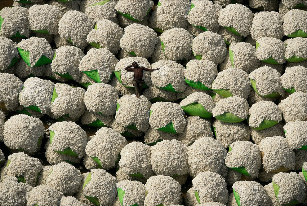
2. Worker resting on bales of cotton, Thonakaha, Korhogo, Ivory Coast. Cotton crops occupy approximately 335,000 square klilometers worldwide, and use nearly one quarter of all pesticides sold. [map] (© Yann Arthus-Bertrand)
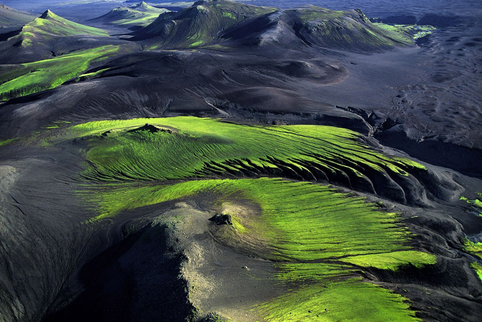
3. Mountainous countryside near Maelifellssandur, Myrdalsjökull Region, Iceland. Once the young lava fields of Iceland cool down, life begins anew little by little. Ice, wind and water flatten and carve out shapes to begin with, then, during the summer, bacteria, lichen and fungi prepare the soil for plants, in particular mosses which adapt to an environment which remains difficult. These plants colonise the most favourable sites and terrain little by little, forming a new ecosystem. [map] (© Yann Arthus-Bertrand)
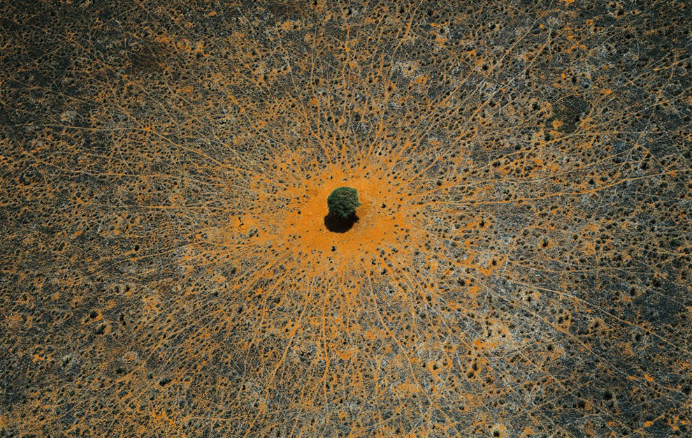
4. “Tree of life”, Tsavo national park, Kenya. This acacia is a symbol of life in the vast expanses of thorny savanna, where wild animals come to take advantage of its leaves or its shade. Tsavo National Park in southeastern Kenya, crossed by the Nairobi-Mombasa road and railway axis, is the country’s largest protected area (8,200 square miles, or 21,000 square kilometers) and was declared a national park in 1948. [map] (© Yann Arthus-Bertrand)
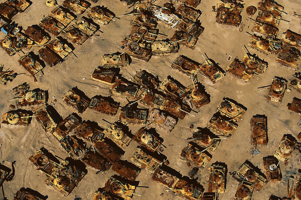
5. Iraqi tank graveyard in the desert near Al Jahrah, Kuwait. This graveyard of tanks will bear witness for many years to the damage that war causes both to the environment and to human health. In 1991, during the first Gulf War, a million depleted uranium shells were fired at Iraqi forces, spreading toxic, radioactive dust for miles around. Such dust is known to have lasting effects on the environment and to cause various forms of cancer and other serious illnesses among humans. [map] (© Yann Arthus-Bertrand) #

6. Village in the Rheris Valley, Er Rachidia region, High Atlas Mountains, Morocco. Fortified villages are frequently seen along the valley of the Rheris, as they are on most rivers of southern Morocco, inspired by the Berber architecture built to protect against invaders. Today, with the threat of raids now gone, the close clustering of dwellings, small windows, and roofs covering houses and narrow streets serve the purpose of protecting occupants from heat and dust. The flat, connecting roofs also provide a place for drying crops. [map] (© Yann Arthus-Bertrand)
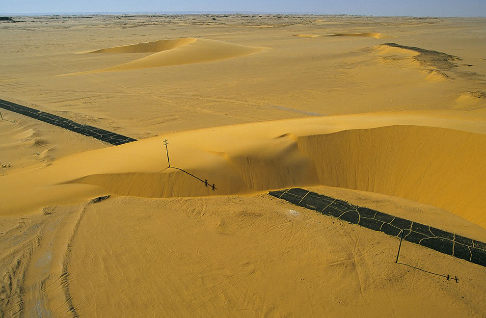
7. Road interrupted by a sand dune, Nile Valley, Egypt. Dunes cover nearly one-third of the Sahara, and the highest, in linear form, can attain a height of almost 1,000 feet (300 m). Barchans are mobile, crescent-shaped dunes that move in the direction of the prevailing wind at rates as high as 33 feet (10 m) per year, sometimes even covering infrastructures such as this road in the Nile Valley. [map] (© Yann Arthus-Bertrand)
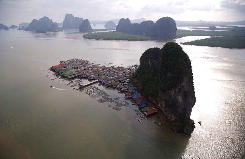
8. Town of Koh Pannyi, Phand Nga bay, Thailand. The south-western coast of Thailand offers a series of beautiful bays lined with many islands. Phang-nga Bay’s special formations were created after the thawing of ice 15,000 years ago. Rising waters then submerged arid calcareous mountains, leaving only their peaks visible to the eye. The bay was turned into a marine park in 1981. One of its popular attractions is the village of Koh Panyi, which was built on piles two centuries ago by Muslim sailors coming from Malaysia. The inhabitants make a living via traditional fishing and tourism. Preserved by its configuration, the bay floor of Phang-nga Bay suffered much less from the tsunami of December 26, 2004 than nearby sites. [map] (© Yann Arthus-Bertrand)
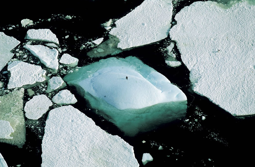
9. Icebergs and an Adelie penguin, Adelie Land, Antarctica. Antarctica, the sixth continent, is a unique observation point for atmospheric and climatic phenomena; its ancient ice, which trapped air when it was formed, contains evidence of the Earth’s climate as it has changed and developed over the past millions of years. [map] (© Yann Arthus-Bertrand)
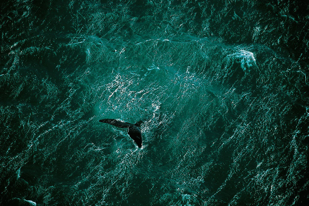
10. A whale swims off the Valdes peninsula, Argentina. After summering in the Arctic, whales return to the southern seas each winter to reproduce. From July to November, whales mate and bear their young along the coasts of the Valdes Peninsula in Argentina. Until the 1950s, this migratory marine mammal was extensively hunted for its meat and the oil extracted from its fat, which brought it to the edge of extinction. Protective measures were adopted after international attention was focused on the problem in 1937. In 1982 a moratorium was declared on whale hunting for commercial purposes, and in 1994 the southern seas became a whale sanctuary. After decades of protection, 7 of the 13 whale species, of which only a few thousand remain (10 to 60 times fewer than in the early 20th century), are still endangered. [map] (© Yann Arthus-Bertrand)
Project “Earth from above”, from photograph Yann Arthus-Bertrand, contains more than 500,000 aerial photos that have been taken in 100 countries from all over the world. Here you will find a selection from them.
1 yorum:
wow - that top foto is one incredible shot....
what a beautiful blog you have!
Yorum Gönder